Winter forecast
Good day, snow-lovers!
Rain has ended our fire season, and the bright colors of Fall have been on fantastic display this past week to remind us Winter will be fast upon us. You may find it early, but up here in the Schweitzer Basin, Fall means it’s time for tire-swaps and carrying chains.
Speaking of weather, we have become accustomed to reading the forecasts provided by a special group of guys called the Powderchasers. The Powderchasers are skiers and riders who track and prognosticate snowstorms. They write the information in a very clear and concise way then hit the road to chase the pow and report the results—it’s pretty fantastic to follow. As a special enhancement, the chief-chaser, Steve, has graciously allowed us to share their forecast with you all. Get stoked because the weather outlook again looks good for our neck of the woods. Enjoy the forecast, and follow the links to learn more.
On the village build-out being undertaken, The Humbird looks awesome, the village plaza will be a new experience for everyone. On the White Pines addition, the 5 needles addiion has been iniatiatyed.
In an upcoming issue, we will go over the results of Selkirk Powder, the timber sale. Started in 2015, the sale will greatly affect the skiing under Big Blue.
Stoked! Less than three months till winter!
— Ken & Co.
Winter weather forecast
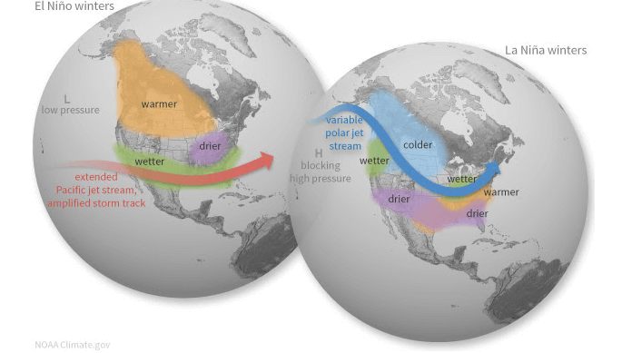
A La Niña Watch has been issued because conditions are favorable for the development of La Niña conditions within the next four months. We have been in an ENSO-Neutral phase recently, which is defined by the surface water temperatures in the equatorial Pacific ocean running near normal compared to long-term averages.
Depending on which phase of ENSO (El Niño Southern Oscillation) we are in, it has big implications of what the upcoming winter will be like.
First off, what happens during each ENSO phase?
Since we are anticipating La Niña conditions, we’ll focus on the right side of this image above. Normally, high pressure will set up off the west coast of North America. Due to this, the storm track will allow for weather systems to track into British Columbia and the Pacific Northwest. This track will bring active weather into the central and northern Rockies, through the Great Lakes region, and into the Northeastern U.S. This can also provide cooler temperatures for these regions.
This is the “typical” setup of what generally happens. Of course, there can be instances where we have a more southerly tracking storm but that should be the anomaly this upcoming season. For example, last season with La Niña, the Southern San Juan range of Colorado (which is not typically favored) started the season with significant snow in November and December. While we can draw conclusions on storm tracks, we are still talking about long-range forecasts that can vary as La Niña is still developing and variability does exist season by season.
When looking at the I-70 corridor of Colorado or the Wasatch of Utah, they often sit on the edge of the active storm track, so they typically don't see any real favoritism with La Niña or El Niño. Even the northern Sierra range can do well with both patterns.
Globally, weather will be influenced by the cooler waters in the Pacific. Our friends across the pond in Japan could expect cooler conditions and a solid ski season ahead.
Long-range forecast
The Climate Prediction Center issues forecasts months well in advance. They take into consideration aspects like which ENSO phase we are in and many other global, regional, and local factors. Their forecast for the upcoming winter show that warmer-than-normal temperatures are expected for the southern and eastern U.S.
This temperature forecast shows that many mountain locations will run with near normal temperatures this winter with slightly warmer-than-normal temperatures expected at some ski areas. Precipitation-wise, this winter is currently forecast to line up with the general thoughts of La Niña.
The northern Rockies, BC, and the Cascades show promise of having more than enough moisture to work with this winter. The question will be: what will the temperatures be like? As we saw last year, we had several big storms, but the rain/snow-line was higher than we wanted with several ski areas seeing more rain than snow at times.
Most ski areas across the country should end with near-normal snow for the entire season.
Key take-aways
Overall, the trend of a La Niña winter is to bring ample snows to the Cascades, the northern Rockies, and the Tetons. La Niña seasons can bring the Sierra Nevada and the Colorado Rockies hit-or-miss snows but enough to have a great season and awesome pow days.
Another factor to note is that when a La Niña winter follows a winter that also had La Niña conditions present (like 2020–2021), the second winter tends to be less impressive in terms of snowfall totals across the U.S.
The Climate Prediction Center is forecasting the winter (which runs from December through February) to have above-normal precipitation in the Pacific Northwest with drier conditions across the southwest.
New Humbird Hotel opening February ’22
Just a quick word about pre-season reservations: because questions are still swirling about the Canadian border staying open, and there’s a buzz about what effect the Ikon Pass will have on Schweitzer skier visits, we haven’t seen traffic like this on the phone or web ever before. Good news: whenever you are ready, Ronnie and Alix are ready to take your reservations. Need help with lodging? give us a call, we can steer you in the right direction.
Check out the new Humbird Hotel located at the base of Schweitzer mountain, offering 31 hotel rooms, full service spa, and restaurant, booking link below. The average room will be $399.00 per night. The new restaurant/bar and added retail facilities will be a tremendous addition to the Village.

